Rangitoto – Auckland’s largest volcano
Rangitoto is the largest and the youngest volcano in the Auckland Volcanic Field. It is one of over 53 volcanoes in the area. Nga Rangi-i-totongia a Tamatekapua – Rangitoto Island was formed by the field’s most recent volcanic eruption around 600 years ago. Apart from its age, Rangitoto differs from other volcanoes around Tāmaki Makaurau Auckland. It has erupted more than once, and it has erupted two different types of lava.

Nga Rangi-i-totongia a Tamatekapua (Rangitoto Island)
Rangitoto is a shield volcano with small scoria cones on top. It is the site of the most recent of Auckland’s volcanic eruptions, around 600 years ago, when Māori already inhabited the area. It is also the largest of the Auckland eruptions, equalling the volume nearly of all previous eruptions combined.
Geological history
Volcanic activity in the Auckland Volcanic Field dates back nearly 200,000 years. Each volcano was fed from the pool of magma that lies under the city, and each eruption occurred at a new location. This pattern changed with Rangitoto. It has erupted at least twice and with different kinds of magma – alkali basalt and subalkaline basalt.
Rangitoto’s initial eruption was wet as the lava encountered seawater. Surges of volcanic ash covered nearby Motutapu Island and caused widespread deforestation. A second eruption ejected different, drier material and built up the island. The eruptions were significant – the 2.3 km³ of material they expelled was nearly equal to all of the Auckland Volcanic Field’s prior eruptions!

Māori fishing camp on Rangitoto
This painting from the mid 1850s shows a fishing camp on the shores of Rangitoto. Sharks were commonly dried and processed in this manner.
Heaphy, Charles 1820-1881 :Rangitoto Id. Extinct volcano. No 2 [1850s?]. Ref: C-025-002. Alexander Turnbull Library, Wellington, New Zealand. /records/23116010
Cultural history
Māori were inhabitants of the local area when Rangitoto formed. Ngāi Tai were living on Motutapu, an island adjacent to Rangitoto, and observed the explosive event. Human and dog footprints on Motutapu solidified and were preserved in ash from the volcanic eruption.
Iwi Māori did not permanently occupy Rangitoto due to its arid, rocky terrain but maintain significant associations with the island. Its name – Nga Rangi-i-totongia a Tamatekapua – refers to Tama-te-kapua, captain of the Arawa canoe, who was injured in a battle there. The name translates to the day that Tamatekapua had a bloody nose (or head). There are several pūrākau regarding the volcano’s creation.
DEVORA – assessing volcanic hazards and risks in Auckland
The DEVORA (DEtermining VOlcanic Risk in Auckland) programme brings together researchers from across Aotearoa New Zealand and beyond to assess volcanic hazards and risks in Auckland. As part of their outreach, the DEVORA team uses infographics to raise awareness about the Auckland Volcanic Field and the importance of understanding the local environment and landscape.

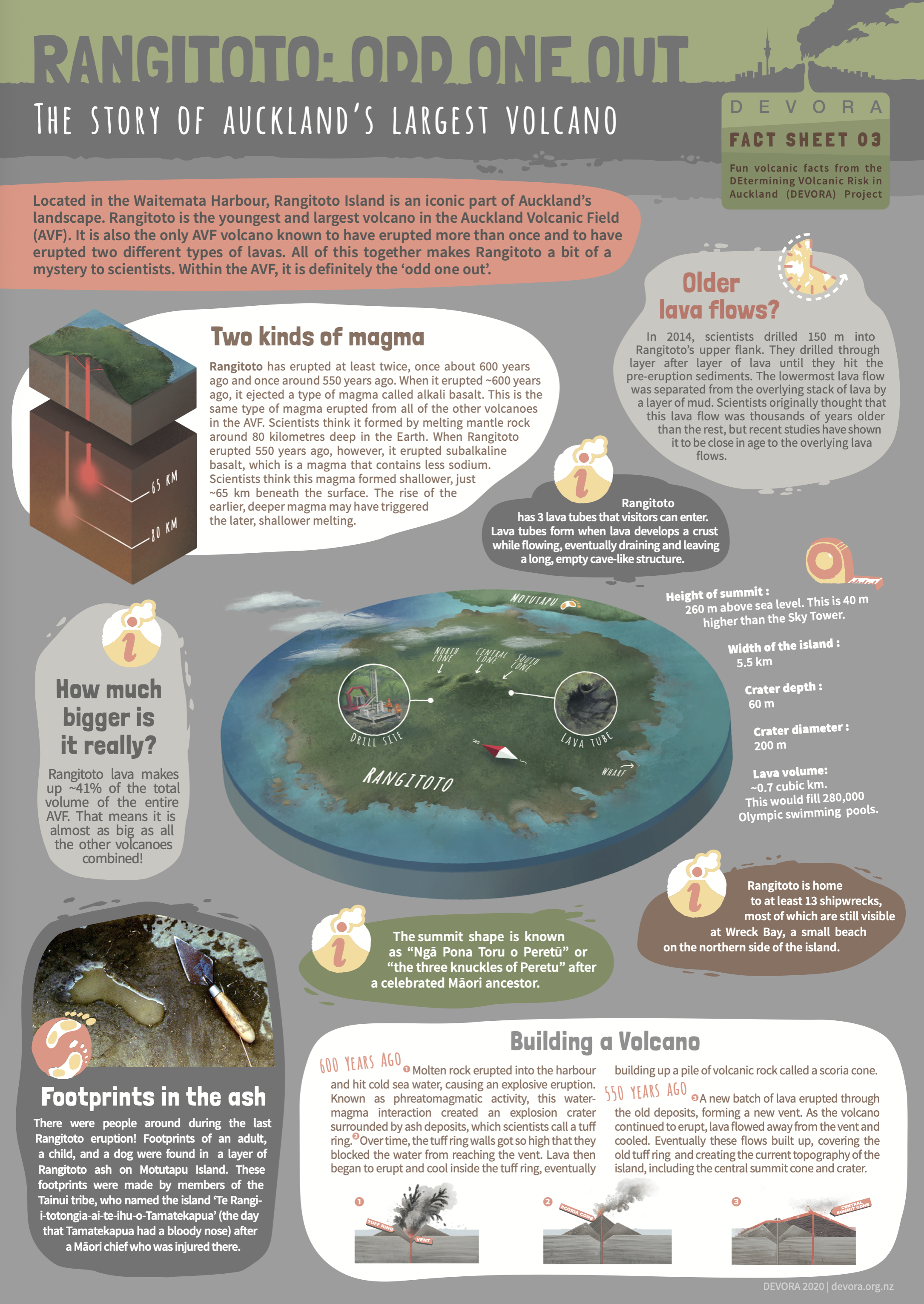
Rangitoto: odd one out – the story of Auckland’s largest volcano
This infographic fact sheet includes information about the formation of Te Rangi-i-tōtōngia-ai-te ihu-o Tamatekapua – Rangitoto Island, its human occupation and importance of Rangitoto to local iwi and more.
Download the infographic as a PDF.
Using infographics as teaching tools
Science knowledge is often communicated through visual representations – graphs, diagrams and infographics. Each type of visual representation has literacy components that ākonga may need support to understand. The science capability ‘Interpret representations’ encourages ākonga to think about how data is presented, what the representation tells us and how it gets the message across.
Interrogate the infographic with questions – for example:
Who created the infographic?
Who is the intended audience?
What is the central theme?
Are there subthemes?
What makes the message credible?
What other information might you need to understand the infographic?
Are there specific scientific words or terms?
Where can you find the information that might fill in these gaps?
By their nature, infographics use concise text, so we’ve placed each DEVORA infographic within an article that includes background information and links to related content. Use them to explore and deepen understanding of concepts within the infographics.
DEVORA’s suite of infographics:
City of volcanoes – the Auckland Volcanic Field Ngā Tapuwae ō Mataaho supported by the article Tāmaki Makaurau – city of volcanoes.
Hidden eruptions – the search for Auckland’s volcanic past supported by the article The search for Auckland’s volcanic past.
Rangitoto: odd one out – the story of Auckland’s largest volcano supported by the article Rangitoto – Auckland’s largest volcano.
Eruption impacts – how would an eruption in Tāmaki Makaurau impact the city? supported by the article Auckland Volcanic Field – eruption impacts.
The floor is lava – lava flows from Auckland’s volcanoes supported by the article Lava flows from Auckland’s volcanoes.
Ngā maunga – a brief history of maunga (mountains) in the Auckland Volcanic Field supported by the article Ngā maunga – Tāmaki Makaurau Auckland’s volcanic field.
Volcanic gas, acid rain and ash from possible future Auckland Volcanic Field eruptions supported by the article Volcanic gases – impacts on air quality.
Nature of science in the curriculum
Developing visual and numerical literacies such as those used in infographics supports students to analyse and interpret data. The infographics also enable students to engage with science in social and cultural contexts.
Related content and activity ideas
The article Volcanoes resources – planning pathways provides additional pedagogical information. It also includes the interactive Planning pathways using volcano resources, in which we curate resources into key science concepts and topics. This curation has a specific focus on Auckland’s volcanoes.
Learn more about different types of volcanic rock. They provide clues about the types of magma involved in volcanic eruptions. Volcanologists read rock core samples like the pages of a book to help them determine what volcanic eruptions happened when and where. This is just one method they use – read about others in this article.
Magma on the move has information about magma, how it forms, how it is released and how it becomes lava.
Activity ideas
Get hands on with the following activities:
Making lava fudge is a tasty demonstration of three different types of volcanic rock.
Work as volcanologists in Lost – a hot rock and Identifying volcanic rocks.
Rangitoto is a cinder cone – make a model using fine sand or other granular materials.
Watching Rangitoto erupt uses the book Rangitoto. Ākonga write their own story of Rangitoto, from the point of view of Māori who were on Motutapu at the time of the eruption.
Useful links
Visit the DEVORA website to learn more about its work – including teaching resources and opportunities for free outreach.
Wikipedia has detailed information about the geology and iwi history of Rangitoto Island and Motutapu Island.
The Department of Conservation has a history of Rangitoto Island.
Acknowledgement
This resource has been produced with the support of DEVORA (DEtermining VOlcanic Risk in Auckland).
DEtermining VOlcanic Risk in Auckland (DEVORA)
DEtermining VOlcanic Risk in Auckland (DEVORA) is a multi-agency, transdisciplinary, collaborative research programme led by volcanologists at the University of Auckland and Earth Sciences New Zealand (formerly GNS Science) and funded by the Natural Hazards Commission Toka Tū Ake (NHC) and Auckland Council.