Like the Sun, stars rise in the eastern horizon and set in the western horizon. Navigators who know the direction and position in which the stars rise and set can use the horizon as a compass. Knowledge of the night sky is the most important of the mental constructs of knowledge needed for wayfinding. The star compass was devised to help navigators memorise this knowledge.

The star compass
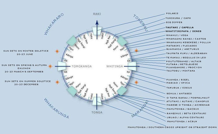
The modern-day star compass (kāpehu whetū) was developed by Polynesian navigator Nainoa Thompson and is based on the Micronesian star compass that grandmaster navigator Mau Piailug originally designed and used. Jack Thatcher made it useful for navigators from Aotearoa by translating it into te reo Māori.
In the star compass, the horizon is divided into quarters – named after the four winds:
- Tokerau – the north-east trade winds
- Marangai – the south-east trade winds
- Tonga (or Whakarunga – the head of the fish) – the south-west winds
- Whakararo (from the tail of the fish) – the north-west winds.
The full horizon is also divided into equal areas called houses. There are 32 houses in the full circle. The four main houses representing north, south, west and east are:
- Whitinga – east where the Sun rises out of the ocean
- Tomokanga – west where the Sun returns to the ocean
- Raki – to the right of the Sun’s passage through the sky
- Tonga – to the left of the Sun’s passage.
In addition to these houses, each quadrant has seven houses that further divide the horizon. Each house is replicated in each quadrant and helps with memorising star position and paths. Stars appear to rise out of the eastern horizon, cross the north/south line (meridian) and set towards the western horizon. Individual stars will rise and set in the same named house. The names of the houses and their meanings are:
- Rā – the Sun
- Kāinga – where the Sun lives
- Ngoi – a land bird (the brown noddy) used by navigators to find land
- Manu – the waka as a bird flying across the ocean
- Ngā Rangi – the heavens are where we get our clues
- Ngā Reo – the navigator listens to the voices of the stars that guide him
- Haka – the void where there are no clues, where the true challenge begins.
This star compass is the basis of the navigation system. The various quadrants and houses, as well as the stars that rise and set in those houses, are then memorised.
Star positions
At least 220 stars need to be remembered. The brightest stars are used for navigating. The star compass shows where the stars will rise and set on the celestial equator – slightly different for our horizon in Aotearoa. Our latitude is roughly 35–45°S below the celestial equator. This means that we can’t see some of the northern stars, and some of the more southern stars such as Māhutonga (the Southern Cross) become circumpolar (don’t set).
As the latitude of the observer moves north or south of the equator, the rising and setting points (azimuths) will begin to shift north for stars north of east and west and shift south for stars south of east and west. The shift is smaller for stars near the celestial equator and greater for stars towards the north and south celestial poles. The shifting is due to the changing angle of the curved surface of the Earth over which the observer sees the sky.
As the observer moves toward the poles, the angles of rising and setting of the stars will tilt closer and closer to the horizon until, at the poles, the stars will not rise or set but circle above the observer. At the North Pole, only the northern half of the celestial sphere is visible. At the South Pole, only the southern half of the celestial sphere is visible.
A star is useful for determining direction when its angle as it arcs through the sky is within 30–35° of the horizon. Beyond this, it becomes difficult to tell exactly where it rose or will set. At the equator, where stars rise perpendicular to the horizon, a star may be traced back to the horizon from a greater altitude.
Meridian pairs
The meridian is an imaginary line from due north to due south passing through the zenith (the point in the sky directly overhead). The meridian is perpendicular to the horizon. Stars move from east to west through the sky and cross the meridian at the midpoint of their journeys from the east horizon to the west horizon. Pairs of stars that cross the meridian at the same time are called meridian pairs and are used to judge where north and south are as well as what latitude the waka might be at. Meridian pairs in the northern sky point north. Pairs in the southern sky point south. For example, the top and bottom stars of the Southern Cross (Gacrux and Acrux) are a meridian pair that point south when the Southern Cross is upright.
Related content
Navigating without instruments – introduction curates our resources on Pacific Ocean navigation. It contains articles and activities about this ancient science.
Watch as Dr Pauline Harris and David Perenara-O’Connell discuss space whakapapa and tātai arorangi and their links to navigation.
Activity ideas
- Constellations in the night sky looks at star legends from cultures around the world.
- Kupe and modern voyaging uses the legend of Kupe to compare ancient and modern navigation techniques.
- How’s your memory? involves the memorisation of the star compass components – just like the real navigators.
- Navigating by the stars introduces students to traditional navigational skills – using the cardinal directions and the Southern Cross.
- Compass treasure hunt uses knowledge of the Sun and Moon to make compass directions and uses these directions in a treasure hunt.
- Puzzling out Pacific migrations is a ready-to-use cross-curricular teaching resource. It uses The Long Pause Connected article as the starting point.
Useful links
On the Polynesian Voyaging Society website find out more about Polynesian wayfinding, including modern methods and techniques of non-instrument navigation, all based on Pacific traditions.
This video clip, Papa Mau, documents the legacy of master navigator Mau Pialiug who revived the art of traditional voyaging and reawakened cultural pride throughout Polynesia.
Stellarium is a free open source planetarium for your computer. Just set your coordinates and you can see a realistic sky in 3D, just like what you'd see with the naked eye, binoculars or a telescope.
